I'm actually very surprised that I'd never seen or hiked this route previously, as it's very close to many favorite spots, including: Spruce Knob, Seneca Creek, and Dolly Sods. I may have viewed it briefly but decided that being a Point-to-Point hike made it logistically more difficult. Regardless, upon reading the description on Hiking Upward, I was sold!
Hikers describe the North Fork Mountain Trail (NFMT) as having "relentless views".
They are correct, there are so many overlooks we couldn't mark them all
on our hike map. If you want a view, walk no more than 25 yards to the
west off the trail and you will find one! HikingUpward
I was excited to get out and see a new trail, and to see the back of Seneca Rock. One caveat was that the trail was mostly dry, maybe a flowing spring about half way through, but not to be counted on. I decided to carry enough water for 2 full days - just over 6L, close to 14 pounds. Even with the water weight my pack was ~32lbs.

We drove separately to accommodate the Point-to-Point hike, leaving before first light on Sunday. We arrived at the northern terminus on Smoke Hole Rd right in Cabin, WV at around 9am and made the 40 min drive down to the southern terminus at the top of North Mountain. The weather had started foggy and misty as we had been driving, but quickly cleared and the temperature was wonderful for hiking.
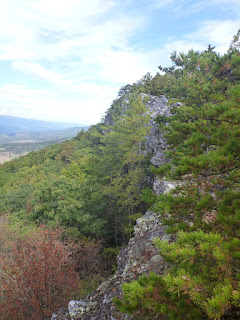


The trail follows the ridge-line for most of the 25 miles, dropping off for short periods of time. Often the trail is only 25 yards away from the ridge top, as the description above states, however, it's still 25 yards off! I wondered why the trail didn't follow the ridge and provide continuous views. But there were plenty of overlooks all the same - the valley overlooking I've driven many times on the way to or from Dolly Sods, or Seneca Creek.


We made very quick time, making it to a great campsite at mile 8 and walking a few more miles to have a great lunch overlooking the western views and Seneca Rock from the reverse side.

At mile 10 we made it to a gas pipe line/forest road and evidence of 4-wheeling, partying, and general red-neckery was clear evident. Beer cans (and shitty beer at that) littered the road for the next two miles, along with other debris. At mile 12 we came to the 12 mile mark and the suggested campsite on Hiking Upward. Keep walking! The campsite is on the road, on a hairpin turn. Littered with piles of beer cans and piles of empty water jugs - evidently people stash water for the hike and then leave their garbage instead of packing it out. Additionally there was a semi-permanent looking tent there with water jugs hoarded around it, so it may be a vagrant living here.

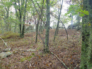
The next few miles the trail left the ridge by a few hundred yards and went through a burned out, eerie section of new growth and charred standing trees.


Mile 16 we found our slice of heaven. A fantastic campsite a ways off the trail, right on a cliff edge. there was a buffer of rocks on the cliff top that acted like a great wind break for the fire.


The following morning, after a great night sleep in the hammock, we made short work of the remaining 8 miles - the last couple of which dived steeply down into the valley and back to my vehicle. The views were again amazing and plentiful! A strenuous but rewarding day hike could be had by parking at the bottom and coming up to Chimney Rock, about a 6 mile out and back.


We made very quick time, making it to a great campsite at mile 8 and walking a few more miles to have a great lunch overlooking the western views and Seneca Rock from the reverse side.

At mile 10 we made it to a gas pipe line/forest road and evidence of 4-wheeling, partying, and general red-neckery was clear evident. Beer cans (and shitty beer at that) littered the road for the next two miles, along with other debris. At mile 12 we came to the 12 mile mark and the suggested campsite on Hiking Upward. Keep walking! The campsite is on the road, on a hairpin turn. Littered with piles of beer cans and piles of empty water jugs - evidently people stash water for the hike and then leave their garbage instead of packing it out. Additionally there was a semi-permanent looking tent there with water jugs hoarded around it, so it may be a vagrant living here.

The next few miles the trail left the ridge by a few hundred yards and went through a burned out, eerie section of new growth and charred standing trees.


Mile 16 we found our slice of heaven. A fantastic campsite a ways off the trail, right on a cliff edge. there was a buffer of rocks on the cliff top that acted like a great wind break for the fire.


The following morning, after a great night sleep in the hammock, we made short work of the remaining 8 miles - the last couple of which dived steeply down into the valley and back to my vehicle. The views were again amazing and plentiful! A strenuous but rewarding day hike could be had by parking at the bottom and coming up to Chimney Rock, about a 6 mile out and back.


No comments:
Post a Comment